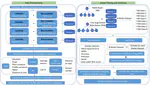
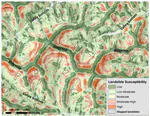
Risk Assessment and Management
The streamline of engineering design evolved from Factor of Safety to Reliability Index, and about to the risk-informed design & management in the foreseeable future. In CGG, we focus on using datasets consisting of aerial photography, geology, soils, hydrologic information, LiDAR (point clouds and DEMS), and infrastructure and residential information, to create machine learning models for geo-hazard analysis and test the probability of failure under different geologic and hydrologic conditions. The results will identify vulnerable areas and the potential impact on the built environment, all of which will be incorporated into mitigation strategies that represent a giant step forward in making community resilient.
Yichuan Zhu
Assistant Professor
My research interests inlcude granular mechanics, remote sensing and applications, uncertainty quantification, and risk assessment and management.