Non-affine georectification to improve the topographic fidelity of legacy geologic maps
Abstract
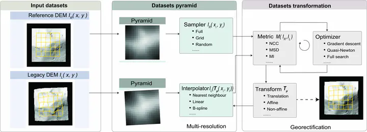
Field-based geologic maps, which are among the most valuable tools of communication among geoscientists, can be expensive and time-consuming to produce or manually revise. We have found that some geologic maps faithful to the topographic maps available at the time the geologic maps were made can have discrepancies with modern digital elevation models produced using airborne lidar. For example, a resistant sandstone shown to align with a prominent set of cliffs on the original topographic base map may be noticeably distant from the same cliffs on the modern digital elevation model. We describe a workflow for the registration of legacy geologic map raster images to modern digital elevation models based on non-affine transformation of a legacy digital elevation model serving as a proxy for the analog topographic contours shown on the geologic map. We demonstrate our approach using three 1960s era 7.5′ geologic quadrangle maps and early generation digital elevation models digitized from photogrammetric contours of similar vintage, showing that the method yields improved fidelity between the legacy geologic map and obvious topographic features as depicted on modern lidar digital elevation models, thus improving the long-term utility and value of the geologic map data.