An intelligent swath tool to characterize complex topographic features: theory and application in the teton range, licking river, and olympus mons
Abstract
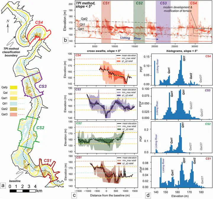
Swath analysis has been useful for linking topography to geomorphic and tectonic processes in a variety of landscapes. Established swath methods have been limited to rectangular or simplified curvilinear sampling blocks despite most geologic structures having complex boundaries and orientations. Moreover, swath boundaries and intervals are commonly defined by arbitrary boundaries and without defined corner points, which makes reproducibility difficult. To address these shortcomings we developed PyOSP (Python Library for Object-oriented Swath Profile), an open-source library that can objectively characterize complex geomorphic boundaries using elevation, slope angle, topographic position index, or other raster calculations by intelligently assimilating geoprocessing information into swath analysis. In addition, PyOSP has post-processing tools (cross-swath, data reclassification, slice, histogram analysis, etc.) and the ability to communicate easily with other GIS software. To evaluate the utility of PyOSP, we used it in three case studies (Teton Range in Wyoming, Licking River in Kentucky, and Olympus Mons on Mars) that illustrate the library’s robustness, from objective quantitative description of the topography to improved insights with post-processing capabilities.