Computational Geosystems Group
Computational Geosystems Group
Home
News
Team
Research
Publications
Blog
Openings
Contact
Light
Dark
Automatic
Research
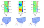
Strain Localization in Sands
Investigate the strain localizaiton phenomena in granular materials
Last updated on Aug 9, 2023
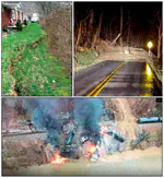
Risk Assessment and Management
Risk=Hazard$\times$Vulnerability$\times$Consequences
Last updated on Aug 9, 2023
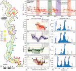
Computational Geosciences
Development of machine learning and remote sensing tools for solving geotechnical and geosicences problems.
Last updated on Aug 9, 2023
Probabilistic Machine Learning and Uncertainty Quantification
Study the impact of aleatory and epistemic uncertainty onto computational models
Last updated on Aug 9, 2023
Cite
×